You have a vacant lot and are building a new home on your parcel
Congratulations!
Summit County & Wasatch County let you build on a vacant piece of land without recording a boundary survey. There are pitfalls to this lack of regulation. (Only surveys that deal with BOUNDARIES are required to be recorded at the County. This includes a Boundary & Topographic Survey.) Topographic‐only surveys are not required to be recorded.
The local governments require a Boundary Survey as part of any remodel or addition work years after your home is built. Why not at the very beginning of the new home process? This is so basic that I have a hard time understanding why these local county building departments don't have stricter requirements regarding initial new builds on vacant lots. Is it a lot in a "Platted Subdivision"? Yes. Does that mean the subdivision map mathematically works or the boundary lot corners are installed correctly? Not always.
The Process
- You hire a surveyor to do a single lot Topographic (aka Topo) survey on your vacant parcel. This map shows the lay of the land with elevation contour lines so that the architect can design your new home.
- After the Topo‐only survey is finished, the architect goes to work.
- Your architect submits the plans to the Building Department for approval.
- Your builder hires a licensed surveyor to stake your new house and driveway.
- The surveyor who stakes your home and driveway is often a different person than your original surveyor.
- FULL STOP. If the previous surveyor did a Topo‐only survey, his survey is not required to be recorded at the County Recorder's office. If this is the case, the prudent surveyor will need to do a Boundary Survey now. Why? Aren't there "boundary lines" shown on the Topo‐only survey? Yes! It LOOKS like a Boundary Survey. (See last page of this paper.) But unless the survey map is filed with the County Recorder, it's often just a Topographic Survey. Your surveyor should therefore retrace the boundary to be sure he is where he thinks he is and then correctly stake the driveway and new home. He is responsible for making sure your new home lies within the building setbacks lines/areas.
- In Summit County, after your house foundation is built, the surveyor who stakes it is REQUIRED to certify to the County that the foundation is in the correct place IN RELATION TO THE BOUNDARY. How can he do this if there was no Boundary Survey of Record at the Summit County Recorder's office? Or if he himself did not retrace the boundary? It's a catch‐22. The County essentially requires Boundary fieldwork AFTER the building plans have been approved and the house has been built.
- In Wasatch County, this house foundation certification step is not even required! Your house could be accidentally be built in the incorrect place by some small amount (a foot or two) yet be over the setback line. No one would see it until years later when you do an updated survey for a remodel or addition to your home. All the more reason for your initial Topographic survey to include a Boundary as part of the work.
- OK, back to the house staking/construction: If the initial survey was Topographic‐only, the construction surveyor either:
- He does a boundary himself right before staking the house and records a Boundary Survey map at the County Recorder's office. Even if all the lot corner rebar & surveyor caps are already in & in the correct positions, if a surveyor retraces a boundary, he is required by state law to file a map of his findings, showing his retracement at that point in time. This almost never happens; not in the budget or not enough time.
- He stakes the house with just enough partial boundary evidence to be confident the house is in the correct place. Is this second method failsafe? No. We've encountered numerous times when a constructed house staked by another surveyor or builder is in the incorrect place.
Wait, isn't the original Subdivision map a Boundary Survey?
Yes. When the subdivision gets recorded, all the lots get marked in the field with boundary corners. In Utah, state law requires a rebar with a cap identifying the surveyor: usually the company name, or license number, or both. But those marks are often destroyed over time. And in certain older local subdivisions, the placed lot corner markers are incorrect compared to the paper subdivision map. Even if the subdivision is brand new, we recommend a boundary retracement.
Example Survey Maps
While there are many types of surveys, two of the most common ones you will likely encounter are a
1) Topographic Survey and a 2) Boundary & Topographic Survey.
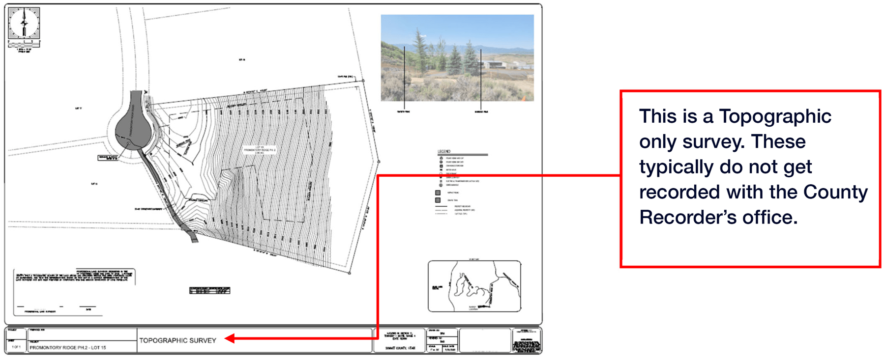
- This says "TOPOGRAPHIC SURVEY". Boundary lines are shown, bearings & distances too! It
looks official & is in fact signed & stamped by a licensed land surveyor. It's a perfectly good
topographic survey & enough for a new home build. However, this will not be recorded at the
County Recorder's office.

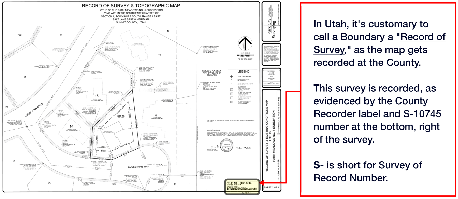
- A Boundary & Topographic survey. It can be confusing to the public, as these maps look
almost identical. The name of the map is "RECORD OF SURVEY & TOPOGRAPHIC MAP".
